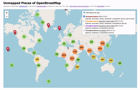
Category: Stats

Review requests of OpenStreetMap contributors
– How you can assist! –

The latest version of the OpenStreetMap editor iD has a new feature: “Allow user to request feedback when saving“. This idea has been mentioned in a diary post by Joost Schouppe about “Building local mapping communities” (at that time: “#pleasereview”) in 2016. The blog post also contains some other additional and good thoughts, definitely worth reading.

However, based on the newly implemented feature, any contributor can flag her/his changeset and ask for feedback. Now it’s your turn! How can you find and support those OSM’ers?

  • Step 1: Based on the “Find Suspicious OpenStreetMap Changesets” page you can search for flagged changesets, e.g. limited to your country only: Germany or UK.
  • Step 2: Leave a changeset comment where you e.g. welcome the contributor and (if necessary) give her/him some feedback about the map changes. You could also add some additional information, such as links to wiki pages of tags (map features), good mapping practices, the OSM forum, OSM help or mailing lists. Based on the changeset comment other contributors can see that the original contributor of this changeset already has been provided with some feedback.

Who is commenting?
An Overview about OSM Changeset Discussions

As mentioned in my previous blog post about detecting vandalism in OpenStreetMap (OSM) edits, it’s highly recommended that contributors use public changeset discussions when contacting other mappers regarding their edits. This feature was introduced at the end of 2014 and is used widely by contributors today. Each and every comment is listed publicly and every contributor can read the communication and, if necessary, add further comments or thoughts. In most cases where questions about a specific map edit come up, it is desirable that contributors take this route of communication instead of private messaging each other.

For my presentation at the German FOSSGIS & OpenStreetMap conference I created several statistics about the aforementioned changeset discussion feature. For this blog post I reran all analyses and created some new charts and statistics. Let’s start with the first image (above): It shows the number of commented or discussed changesets per month since its introduction. The peak in January, 2017 is based on a revert with several thousands of changesets.

Detecting vandalism in OpenStreetMap – A case study

This blog post is a summary of my talk at the FOSSGIS & OpenStreetMap conference 2017 (german slides). I guess some of the content might be feasible for a research article, however, here we go:

Vandalism is (still) an omnipresent issue for any kind of open data project. Over the past few years the OpenStreetMap (OSM) project data has been implemented in a number of applications. In my opinion, this is one of the most important reasons why we have to bring our quality assurance to the next level. Do we really have a vandalism issue after all? Yes, we do. But first we should take a closer look at the different vandalism types.

It is important to distinguish between different vandalism types. Not each and every unusual map edit should be considered as vandalism. Based on the OSM wiki page, I created the following breakdown. Generally speaking, vandalism can occur intentionally and unintentionally. Therefore we should distinguish between vandalism and bad-map-editing-behavior. Oftentimes new contributors make mistakes which are not vandalism because they do not have the expert mapper knowledge. In my opinion, only intentional map edits such as mass-deletions or “graffiti” are real cases of vandalism.

A comparative study between different OpenStreetMap contributor groups – Outline 2016

Over the past few years I have written several blog posts about the (non-) activity of newly registered OpenStreetMap (OSM) members (2015, 2014, 2013). Similarly to the previous posts, the following image shows the gap between the number of registered and the number of active OSM members. Although the project still shows millions of new registrations, “only” several hundred thousand of these registrants actually edited at least one object. Simon showed similar results in his yearly changeset studies.

2016members

The following image shows, that the project still has some loyal contributors. More specifically, it shows the increase in monthly active members over the past few years and their consistent data contributions based on the first and latest changeset:

2016months

However, this time I would like to combine the current study with some additional research. I tried to identify three different OSM contributor groups, based on the hashtag in a contributor’s comment or the utilized editor, for the following analysis:

Verified OpenStreetMap contributor profiles?

The reputation of a contributor in OpenStreetMap (OSM) plays a significant role, especially when considering the quality assessment of the collected data. Sometimes it’s difficult to make a meaningful statement about a contributor by simply looking at the raw mapping work represented by the number of created objects or used tags. Therefore, it would be really helpful if we would have some additional information about the person who contributes to the project. For example: Does she/he help other contributors? Is her/his work somehow documented or based on one of the “discussed” proposals? Or does she/he work as a lone warrior in the OSM world?

In 2010 I created “How did you contribute to OpenStreetMap?” (HDYC) as a kind of fun side project. Nowadays many people use it to get some detailed information about OSM contributors. Some of you are probably familiar with the “verified” icon used on some celebrity Twitter accounts. I created a similar new feature for the aforementioned HDYC page. If you connect your related OSM accounts, your profile will be marked as “verified”.

How to detect suspicious OpenStreetMap Changesets with incorrect edits?

Since its rise in popularity, the well-known online encyclopedia Wikipedia has been struggling with manipulation or, in the worst-case, vandalism attempts. Similarly, the OpenStreetMap (OSM) project suffered several times over the past few years of cases where incorrect map data edits were made. These erroneous edits can stem at times from (new) contributors or illegal data imports (or automated edits) which have not been discussed in advance with the community or the Data Working Group (DWG) and corrupted existing project data. The current OSM wiki page gives a great overview about general guidelines and e.g. types of vandalism. Another page in the wiki also mentions a prototype of a rule based system for the automatic detection of vandalism in OSM, which I developed in 2012. However, the system has never actually been implemented. Today, the contributors of OSM can use a variety of different tools to inspect an area or particular map changes. A few of them are listed below (complete list can be found here):

OpenStreetMap Crowd Report – Season 2015

Almost one year has passed again. This means it’s time for the fourth OpenStreetMap (OSM) member activity analysis. The previous editions are online here: 2014, 2013 and 2012. Simon Poole already posted some interesting stats about the past few years. You can find all his results on the OSM wiki page. However, similar to last year, I try to dig a little deeper in some aspects.

Overall the OSM project has officially more than 2.2 million registered members (Aug, 9th 2015). For several of my OSM related webpages I create a personal OSM contributor database, based on the official OSM API v0.6. Anyway, when using this API, the final table will show a list with more than 3 million individual OSM accounts (Aug, 9th 2015). I’m not sure what the cause for this gap of almost 1 million members between the official number and the member number extracted with the API could be. Maybe some of you have a possible explanation? However, I think many accounts are created by spammers or bots.

Counting changes per Country – A different approach

OSMstats contains several statistics about the OpenStreetMap (OSM) project, such as daily-created objects, the amount of active contributors or detailed numbers for individual countries. One way to determine the sum of created or modified Node objects, is to use the minutely, hourly or daily OSM replication change files and counting the values for each country of the world. Sadly, this approach has some drawbacks. Firstly, the official files do not contain, for example, all Nodes of a modified way, which is required, when trying to find the country where the change took place. Furthermore, the determination of the country for a specific OSM object really depends on the border’s level of detail: More detailed country borders make the processing quite time-consuming. Some of you probably experienced this problem before when using Osmosis or a different OSM processing tool. Anyway, for calculating additional country statistics I tried a new approach:

  1. Determine the country of a changset based on its center position
  2. Use the changeset country information for all objects within this changeset.

Ebola Response Map and OSM contributor analysis

For almost eight months the OpenStreetMap (OSM) community has been collecting geo information for the West Africa Ebola outbreak response now. The collective work of the crowd is somewhat managed by the Humanitarian OpenStreetMap Team (HOT). For example, the Task Manager provided by HOT gives interested contributors information in which areas map features are needed. However, you can find additional information in an article by Pierre Beland, which he wrote during a conference where he presented the efforts of the OSM community. The OSM wiki contains some useful information about the West Africa Ebola Response too. Matt Irwin also wrote a summary about the OSM mapper contributions and created an interesting visualization of all the mapping work.

I created a response map for the OSM mapping activities in West Africa, a similar approach as I previously used for the “Typhoon Haiyan” deployment. It displays all OSM changesets created since March 1st, 2014. The analysis extent is displayed by a black rectangle. In total, more than 2,000 contributors made more than 10 million changes to the map. At the bottom you will find a time range slider which can control the displayed changesets. Sorry for the sometimes slow performance, but the community (maybe you too) collected a huge amount of data! The map is online here: http://resultmaps.neis-one.org/osm-ebola

Welcome to an additional family member – OSMstats

Maybe some of you are already familiar with “OSMstats”, a website that provides numerous statistics about the OpenStreetMap (OSM) project. The site was created and is maintained by the two guys at altogetherlost.com. However, OSMstats has now been moved to the ResultMaps domain at osmstats.neis-one.org. I added several new features too. First of all, you can now select a specific date for your stats. Secondly, the main menu panel has been extended with a new entry for statistical information about OSM changesets.

osmstats

Additionally, the graphs for the country statistics, the active members and daily edits are also available in a “year”-overview. I hope you like the new extensions. A big thanks to both guys at altogetherlost.com who originally created OSMstats!

OSMstats is now available at: http://osmstats.neis-one.org
Feel free to check out my Resultmaps too which offer many helpful and funny OSM tools: http://resultmaps.neis-one.org

Notice: OSMstats was introduced in 2011, this means the webpage cannot provide statistics prior to that year. Also, the newly created Changeset-Tab has only data for July, 2014 and after.