As you may know by now, the Philippines have been struck by one of the largest Super Typhoons ever recorded. Many casualties are expected (especially in Tacloban) and even more people are in need of help. While some of us have been busy working with the “Stand By Task Force” to analyze and geolocate tweets with useful information, the Humanitarian OpenStreetMap Team (HOT) has been making progress as well.
I have spent some time to develop a website that visualizes the latest changes to the OSM map (utilizing changesets) in the Philippines and hope that it helps to determine areas that might be already worked on, while other areas are lacking any new information. You can find the map here: http://resultmaps.neis-one.org/osm-typhoon-haiyan-2013
Additional information can also be found in the OSM Wiki and for all German fellows at the Wochennotiz blog, in case you are interested in actively contributing and helping the disaster response teams. Any mapping efforts are much appreciated!
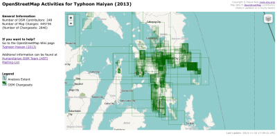
Some statistics: Until midnight between Saturday and Sunday (November 9th/10th), almost 180 contributors made more than 245,000 map changes. On Sunday evening 6pm UTC (November 10th, 2013) the values increased to 245 volunteers who created nearly 440,000 map changes within the aforementioned extent. AWESOME, keep up that great work! Thank you.
Link to the website: http://resultmaps.neis-one.org/osm-typhoon-haiyan-2013
Some technical background information: The minutely changeset diff files are imported in a PostgreSQL database. The created website only visualizes the changesets which are within a predefined extent, i.e. the Philippines and some parts of the Vietnam coast. This extent is illustrated by a black line on the website. The OSM changeset data is updated on an hourly basis.
Thanks to maɪˈæmɪ Dennis
Comments
4 responses to “Typhoon Haiyan OSM Response Map”
[…] kl. 22:30 – Pascal Neis har også skrevet om weekendens indsats i “Typhoon Haiyan OSM Response Map“. Der er lavet to visualiseringer der ændrer sig med nye statistiske oplysninger om […]
Great visualization! Shows what a great tool such an share able update able map is in such situations.
P.S
Some of these captchas are hard to read even to me as a human.
[…] Haiyan causing tragic destruction in the Philippines, there is currently a relief effort underway. Read more here and get involved if you […]
[…] Typhoon Haiyan OSM Response Map >> Neis One! […]