The last unmapped places analysis for OpenStreetMap that I conducted is nearly eight months ago. So I figured it was about time to create a new one. You can read in the last blog post how my algorithm exactly works.
However, at the moment (Nov. 4th. 2011) we have (according to the Geofabrik extract) about 597 000 entries in OSM for places that are located within “Europe“. This means we have an overall increase of about 90 000 places within the past eight months. We can separate them into several types with different values:
- City: 1093 (as of March 11th, 2011 it was 1055 ; +3.6%)
- Town: 16213 (as of March 11th, 2011 it was 16106 ; +0.7%)
- Suburb: 29642 (as of March 11th, 2011 it was 24913 ; +19.0%)
- Village: 301638 (as of March 11th, 2011 it was 278691 ; +8.2%)
- Hamlet: 238717 (as of March 11th, 2011 it was 184326 ; 29.5%)
- Isolated dwelling: 9064 (new in my stats)
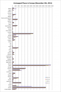
The results showed that of the total 301638 village entries for Europe in the database, about 154445 (51%) (in March 2011 it was 55%) have not been detected or mapped yet. Further it is possible that the places are tagged incorrectly (e.g. villages vs. hamlet). Anyway, the following figures show the distribution of the values for each country (in different scales).
 |
 |
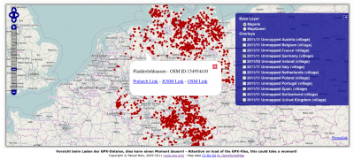
It is nice to see, that Austria (-688), Czech Republic (-633), France (-1978), Georgia (-721), Germany (-1192), Italy (-926), Poland (-2364), Spain (-1472) and the United Kingdom (-829) were able to reduce their “unmapped places” in a quite solid way. As usual you can find my results as a GPX-overlay here: http://resultmaps.neis-one.org
(Remarks for http://resultmaps.neis-one.org: Not each and every country is available as an overlay. Some countries such as France or Poland showed longer browser loading times to display the GPX-overlays!)
UPDATE: Download the complete GPX-files of this analysis here.
thx @ maɪˈæmɪ Dennis

Comments
14 responses to “Updated Status for Unmapped Places”
Thanks for this analysis Pascal 🙂 BTW can you please fix the post, that we can maximize the graphs, please?
uih, thx for noticing!
hello Pascal,
I can’t see France in the stats, sorry but as I work on this country, I’d like to have information on it !
Please …
Thanks for all your stats and tools,
Bazgal.
Hi Bazgal,
did you see this? http://neis-one.org/wp-content/uploads/2011/11/20111104_UnmappedPlaces.png
It is the left of the above figures. Or did you see the France GPX Overlay here: http://resultmap.neis-one.org/
Cheers,
Pascal
great analytics,
can you maybe add israel to your statistic.
i see syria and libanon in your stats, so its very nearby 🙂
i have already fixed soo many problems based on your error analtics in israel. thankyou.
openstreetmap project israel
is it possible to download the data for countries that are not on the map? Thank you
Hi Thomas,
you can find all results here: http://neis-one.org/wp-content/uploads/2011/11/20111104_Europe_Unmapped.zip
Cheers,
Pascal
From a random check on UK points i’d say that highway=”unclassified” will be responsible for a lot of fails.
Should highways=”tertiary” be accepted as a valid ‘village road’?
Hi Jez, thanks for your comment.
Sadly, yes, it seems that some streets are not tagged the right way. Maybe some people don’t know that the highway=unclassified tag is mapping the interconnecting street network, e.g. between two villages and that it is not used for tagging some road of an unknown classification. Also, I think it is not good for the results to accept a tertiary road as a “valid village road”.
Cheers,
Pascal
Your data is falsified and useless, because you don’t not include roads: tertiary, secondary and primary.
Much of villages is located on such roads and not have another highway nearby.
Hi Zbigniew, thanks for your comment!
Ok, in Poland there are a lot of errors, but in my opinion and referred to the OSM wiki[1]: a small “village” with only a just a few houses should tagged as a hamlet. Or are there in Poland accumulations of houses with no streets like residential, service, living_street, cycleway or footway? I can not belive it …
Regards,
Pascal
[1] http://wiki.openstreetmap.org/wiki/Map_Features#Places
Yes, Pascal.
There’s a lot of polish villages that’s have no residental streets but lays along tertiary or secondary road.
http://en.wikipedia.org/wiki/Linear_village
http://pl.wikipedia.org/wiki/Chlina
Please, look at these link’s, there’s example of “ulicówka” village, typical for villages in central and northern Poland.
[…] analisis actualizado para lugares no mapeados en OSM […]
[…] updated analysis for unmapped places in OSM […]