Category: Unmapped
-
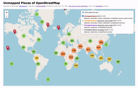
Unmapped Places of the OpenStreetMap World – 2024
In 2010, I first conducted a study which identified regions (places) in the OpenStreetMap (OSM) project in Germany that still had potential for more detailed mapping. Later, in 2016, this analysis was repeated and extended to the entire world. I have since regularly carried out these studies and published the results. The algorithm and some…
-
Unmapped Places of OpenStreetMap – 2016
Back in 2010 & 2011 I conducted several studies to detect underrepresented regions a.k.a. “unmapped” places in OpenStreetMap (OSM). More than five years later, some people asked if I could rerun the analysis …
-
Updated Status for Unmapped Places
The last unmapped places analysis for OpenStreetMap that I conducted is nearly eight months ago. So I figured it was about time to create a new one …