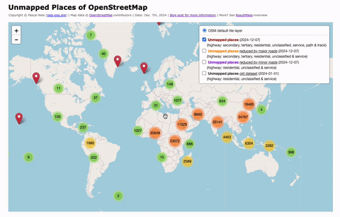
Tag: Unmapped

Unmapped Places of OpenStreetMap – 2016

Back in 2010 & 2011 I conducted several studies to detect underrepresented regions a.k.a. “unmapped” places in OpenStreetMap (OSM). More than five years later, some people asked if I could rerun the analysis. Based on the latest OSM planet dump file and Taginfo, almost 1 million places have been tagged as villages. Furthermore, around 59 million streets have a residential, unclassified or service highway value. My algorithm to find unmapped places, works as follows:

  1. Use every place node of the OSM dataset which has a village-tag (place=village).
  2. Search in a radius of ca. 700 m for a street with one of the following highway-values: residential, unclassified or service.
  3. If no street can be found, mark the place as “unmapped”!

My results for the entire OSM planet can be found under the following webpage.

unmapped

Updated Status for Unmapped Places

The last unmapped places analysis for OpenStreetMap that I conducted is nearly eight months ago. So I figured it was about time to create a new one. You can read in the last blog post how my algorithm exactly works.

However, at the moment (Nov. 4th. 2011) we have (according to the Geofabrik extract) about 597 000 entries in OSM for places that are located within “Europe“. This means we have an overall increase of about 90 000 places within the past eight months. We can separate them into several types with different values:

  • City: 1093 (as of March 11th, 2011 it was 1055 ; +3.6%)
  • Town: 16213 (as of March 11th, 2011 it was 16106 ; +0.7%)
  • Suburb: 29642 (as of March 11th, 2011 it was 24913 ; +19.0%)
  • Village: 301638 (as of March 11th, 2011 it was 278691 ; +8.2%)
  • Hamlet: 238717 (as of March 11th, 2011 it was 184326 ; 29.5%)
  • Isolated dwelling: 9064 (new in my stats)

The Return of “Unmapped Places in OSM EU”

My last blog post about “Unmapped Places in Europe” was read by more then 800 people. So I think it’s time to redo the analyses a second time after three months. At the moment (March 11th, 2011) we have (according to the Geofabrik extract) 505091 places in OpenStreetmap Europe. They can be separated into the following place-types:

  • city=1055 (as of Dec. 5th, 2010 it was 1045 -> +1%)
  • town=16106 (as of Dec. 5th, 2010 it was 16032 -> +0.5%)
  • suburb=24913 (as of Dec. 5th, 2010 it was 23563 -> +6%)
  • village=278691 (as of Dec. 5th, 2010 it was 271147 -> +3%)
  • hamlet=184326 (as of Dec. 5th, 2010 it was 165804 -> +11%)

During my last and also during this analysis I *only* used those places that had a corresponding “village”-value. My tool works so far as followed:

  1. Get only places with a village-tag.
  2. Search nearby (ca. 600m distance) for a street with one of the following highway-types: residential, service, living_street, cycleway, footway, pedestrian, steps or platform.

“Unmapped” Places in Europe?

Recently some new posts on the German OpenStreetMap-Mailing-List regarding the coverage of yet undetected regions in OpenStreetMap have been accumulating, caused by the current clearance of the BING-aerial images.

In one of my former blog posts that I wrote back in August this year, I introduced an analysis that included the search for “places” such as small villages etc. in Germany that probably had not been mapped in OSM at that time (the post in German language can be found here).

However, I repeated this analysis using the database of the routing view. This time I expanded the research area to entire Europe. In total there are 477591 places in Europe covered in OSM (at the moment). They can be separated into the following place-types:

  • city=1045
  • town=16032
  • suburb=23563
  • village=271147
  • hamlet=165804

During my analysis I *only* used those places that had a corresponding “village-tag”. For the case of Germany it can be assumed that places with “higher” place-type tags such as “town” or “city” have already been mapped. In the special case of the “hamlet”-tag there were too many “false=positives” included, thus they could not be considered during the analysis.