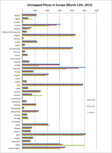
My last blog post about “Unmapped Places in Europe” was read by more then 800 people. So I think it’s time to redo the analyses a second time after three months. At the moment (March 11th, 2011) we have (according to the Geofabrik extract) 505091 places in OpenStreetmap Europe. They can be separated into the following place-types:
- city=1055 (as of Dec. 5th, 2010 it was 1045 -> +1%)
- town=16106 (as of Dec. 5th, 2010 it was 16032 -> +0.5%)
- suburb=24913 (as of Dec. 5th, 2010 it was 23563 -> +6%)
- village=278691 (as of Dec. 5th, 2010 it was 271147 -> +3%)
- hamlet=184326 (as of Dec. 5th, 2010 it was 165804 -> +11%)
During my last and also during this analysis I *only* used those places that had a corresponding “village”-value. My tool works so far as followed:
- Get only places with a village-tag.
- Search nearby (ca. 600m distance) for a street with one of the following highway-types: residential, service, living_street, cycleway, footway, pedestrian, steps or platform.
- If no street can be found, mark the place as “unmapped”!
Why did I only use villages? Well for the case of Germany it can be assumed that places with “higher” place-type tags such as “town” or “city” have already been mapped.
What are the “false=positives” and why is your village marked as unmapped? A village should usually have at least one of the roads mentioned above otherwise the place should be mapped as a hamlet. Would you agree with this?
The results showed that of the total 278691 villages, about 152337 (55%) (in Dec. 2010 it was 58%) who are located within “Europe”, have not been detected or mapped yet. The following diagram shows the distribution of the numbers by country.
 |
 |
YAY, Germany!!!
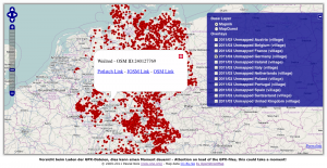
The results can again be displayed as a GPX-overlay on a map which can be found here http://resultmaps.neis-one.org :
(Remarks for http://resultmaps.neis-one.org: Not each and every country is available as an overlay. Some countries such as France, Poland and Ukraine showed longer browser loading times to display the GPX-overlays!)
thx @ Dennis

Comments
14 responses to “The Return of “Unmapped Places in OSM EU””
Thanks for this nice analysis, Pascal. There’s a lot of work left in my neighborhood 😉
I also found a little typo in your diagrams. You wrote “03/11/2010” in the headlines.
Greetings,
Mario
oops, thx! is now fixed 🙂
Hallo Pascal,
ich habe mir mal wahllos einen Punkt in Deutschland angesehen. Platz Hohn (kein Scherz, erster Treffer: http://www.openstreetmap.org/browse/node/1129854562 ) und habe mir das Bing-Luftbild rüber gelegt. Abgesehen davon, dass der Punkt auf place=hamlet abgestraft werden sollte, sehe ich aber in 220 Meter Entfernung eine Straße L352 von Typ secondary ( http://www.openstreetmap.org/browse/way/9209368 , der Weg existiert schon länger). Das ist deutlich unter den angegebenen 600 Meter als unmapped place.
Was kann jetzt dort die Ursache für die Fehlmeldung sein?
Hi Georg,
du beantwortest dir deine Frage eigentlich fast selbst 🙂
“Abgesehen davon, dass der Punkt auf place=hamlet abgestraft werden sollte …”.
Wäre die Place-Node nicht als village sondern als hamlet getaggt (so wie du auch geschrieben hast), würde sie nicht in meine Analyse fallen.
Sollte es dennoch ein village sein, zählt aber trotzdem die naheliegende Straße nicht, weil sie von Typ secondary ist. Wenn müsste eine Straße vom Typ: residential, service, living_street, cycleway, footway, pedestrian, steps oder platform um die Place-Node herumliegen. Klar was ich meine ?
viele gruesse
pascal
Interesting analysis and it is nice to see progress. However, I think the statistic overestimates the number of unmapped places. I have looked at the results map and at a few villages in Germany. I could see following errors:
– Village was placed near a track, not any of your specified roads
– Village node was placed outside the actual maped village or far from nearest road
– Some Village nodes are placed in the middle of nowhere (e.g. a wood)
What is the source of these Village nodes?
Thanks for your great statistics!
Hi and thanks for your comments. You are definitely right. This means though that some of the errors can be fixed by you too ;), I think some village nodes are partially imported from OpenGeoDB. Can anyone confirm this?
nice work Pascal. Did you also look at places as polygons (I guess they will all be mapped with more then one street)? Could you add place=isolated_dwelling to the initial statistics?
What was perplexing me: why did you extend the highway list to cycleway, footway, steps and platform? At first glance I thought that a village with only those would be quite strange if not impossible, but maybe you found in your testing that they were necessary for better results?
@ Martin
Up to now, I do not look at places which were mapped as polygons. “isolated_dwelling” is new to me, I try to add it for the next stats. There are no particular reasons why I add the lower highway types to my analysis, I include them mainly for completeness reasons. I have not tried the analysis without these highway types yet. Maybe I can try this next time …
Hallo,
schöne Statistik, wahrscheinlich auch eine Menge Arbeit.
Allerdings fehlt mir eine weitere Auswertung in Prozent oder wenigstens die Zahl wieviele Dörfer es bei deiner Rechnung pro Land theoret. sein sollten.
Derzeit ist die Wirkung der Zahlen etwas irritierend. San Marino voll erfasst, mag ja angehen, aber Tunesien auch?
Ich denke die absoluten Zahlen der Fehlstände sind einfach nicht besonders ausagekräftig.
In Spanien gibt es laut spanischer OSM Seite um die 7500 Dörfer, da wären bei aktuell fehlenden ~5000 gerade mal ein Drittel erfasst, in Deutschland vermutlich mehr als 90%, denn dein Kriterium ist ja nicht besonders hart.
Wie erklären sich die Länder bei denen die Zahl der unmmapped villages (stark) gewachsen ist? ES sollten doch tendenziell weniger werden.
Viele Gruesse
Martin
@Martin
was meinst du damit genau: “Allerdings fehlt mir eine weitere Auswertung in Prozent oder wenigstens die Zahl wieviele Dörfer es bei deiner Rechnung pro Land theoret. sein sollten.” Ich denke du meinst die Zahlen der Dörfer pro Land insgesamt in OpenStreetMap ? Stimmt, die habe ich oben gar nicht drin, werde sie beim nächsten Mal mit rein nehmen 🙂
Bzgl. San Marino & Tunesien: Tunesien ist nur deshlab in meiner Statistik, weil es in meiner BBox von “Europa” enthalten ist. Leider sind die Werte für Tunesien dadurch eigentlich nicht nutzbar, weil das Land nicht komplett in meinerm BBow dirn ist, werde sie beim nächsten Mal herausnehmen.
Jupp, die Frage hast du richtig erkannt. Ich möchte gern auf einem Blick sehen, in welchem Land es sich noch lohnt einen Urlaub einzulegen ;). In D muss man ja schon die Hausnummern und Parkbäume angehen um nch etwas zum mappen zu haben, so mein Eindruck. Schade das du aktuell diese Zahlen nicht vorliegen hast.
Die letzte Frage bleibt ungeklärt. In Kroatien, Finnland, Serbien und ein paar europ. Nachbarstaaten wie Algerien werden die unmapped villages mehr, nicht weniger. Auch ein Problem mit dem erfassten Gebiet?
naja, deinen Urlaub musst du nicht extra im Ausland planen 😉 in DE gibt es noch mehr als genug zu tun. Sieht man ja auch an den Unmapped Places für DE. Zu Deiner Frage wegen den Ländern wie Kroatien, Finnland usw. dort tritt folgendes auf: Es werden neue Place Nodes für Dörfer in OpenStreetMap erfasst, aber die Straßen fehlen noch, deshalb ist dort ein Anstieg der Unmapped Places zu sehen!
Don’t switch on Poland unless you have a fast computer!
It would be great to expand to other countries as well.
I looked at a random spot in France that was missing a village. Upon inspection there was just a wood where the point was and the surrounding small hamlets each had a name.
I’m guessing this village is really a municipality of those small hamlets and with the center point between them.
So this needs to be done with care if my guess is right.
Thanks for a fantastic map.