Category: Allgemein
-

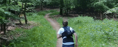
Ein Abenteuer mit der Thermaldrohne: Kinderfeuerwehr auf Vermisstensuche
Drohnen sind aktuell in aller Munde. Leider allerdings eher im Kontext weltweiter Konflikte und geopolitischer Spannungen. Auch wenn ihr Ursprung in der militärischen Entwicklung liegt, werden sie heute vielseitig eingesetzt: zur Freizeitgestaltung, in der Vermessung sowie bei Hilfsaktionen. Genau hier möchte ich anknüpfen. Durch die Hochschule Mainz habe ich Zugriff auf unterschiedliche Drohnensysteme. Von Fluggeräten…
-
From Sky to Trail: Testing GPS Accuracy with Drones, Action Cam and Smartwatch
In the early days of mapping and cartography experiments, GPS tracks were often the starting point. Contributors to the OpenStreetMap (OSM) project, especially before 2010, relied heavily on GPS devices. They would walk or cycle routes and later upload their recorded tracks and observations to OSM. Today, GNSS-capable devices are everywhere: smartphones, smartwatches, action cams,…
-
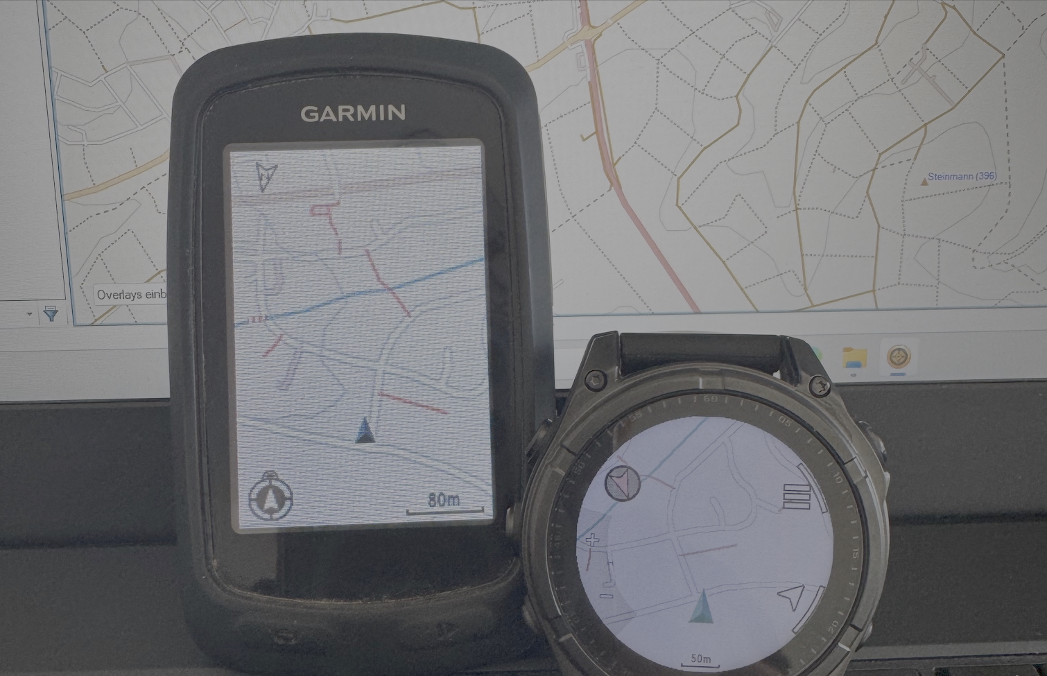
Building My Own Garmin™ Maps for Outdoor Activities Based on OpenStreetMap Data
For many years, I’ve used pre-made Garmin maps from the internet on my devices while hiking, running, or mountain biking. These maps have always been based on data from the OpenStreetMap (OSM) project. In the early days, a map of Europe was just a few hundred megabytes in size and usually fit comfortably on the…
-
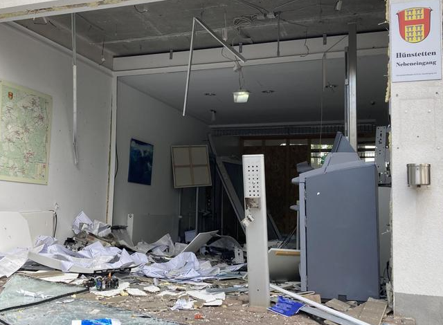
Zwischen Wissenschaft und Kriminalität: Geldautomatensprengungen in Rheinland-Pfalz & Hessen
In den vergangenen Jahren kommt es in der gesamten Bundesrepublik Deutschland immer wieder zu Geldautomatensprengungen. Das Bundeskriminalamt veröffentlicht hierzu jährlich ein Bundeslagebild, das sowohl deskriptive Statistiken als auch weitere Informationen zu den Vorfällen in den einzelnen Bundesländern bietet. Auch in meiner Heimatgemeinde Hünstetten wurde bereits mehrfach ein Geldautomat gesprengt und ausgeräumt. Für mich persönlich war…
-
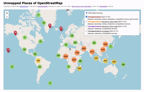
Unmapped Places of the OpenStreetMap World – 2024
In 2010, I first conducted a study which identified regions (places) in the OpenStreetMap (OSM) project in Germany that still had potential for more detailed mapping. Later, in 2016, this analysis was repeated and extended to the entire world. I have since regularly carried out these studies and published the results. The algorithm and some…
-
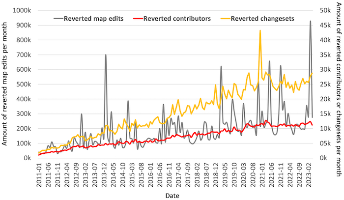
Wait, someone did what?
Exploring Reverted Map Edits in OpenStreetMapThe OpenStreetMap (OSM) project has over 10 million registered members, with around 2 million user profiles having made at least one map contribution. However, a closer look reveals that there has been a slight decline in the number of active contributors over the last three years. Despite the extensive global mapping community, there are instances…
-
#100 – Thank you!
While I was working on my latest blog post, I realized that I had already written 100 posts over the past nine years. All posts have one thing in common: They are about the well-known and maybe never ending OpenStreetMap project …
-
Processing compressed OpenStreetMap Data with Java
This blog post contains a summary on how you can write your own Java classes to process OpenStreetMap (OSM) pbf files. PBF is a compression format, which is nowadays more or less the standard utilized for reading and writing OSM data quickly. In the OSM world, many tools and programs implemented this file format…
-
How to detect suspicious OpenStreetMap Changesets with incorrect edits?
Since its rise in popularity, the well-known online encyclopedia Wikipedia has been struggling with manipulation or, in the worst-case, vandalism attempts. Similarly, the OpenStreetMap (OSM) project suffered several times over the past few years of cases where incorrect map data edits were made. These erroneous edits can stem at times from (new) contributors or illegal…
-
OpenStreetMap Crowd Report – Season 2015
Almost one year has passed again. This means it’s time for the fourth OpenStreetMap (OSM) member activity analysis. The previous editions are online here: 2014, 2013 and 2012 …