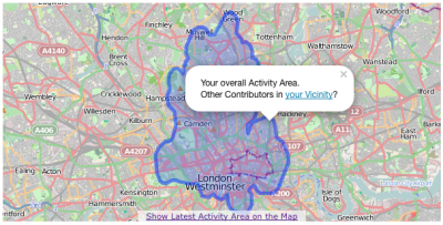
One month ago I wrote a blog post about a new website which allows you to see other OpenStreetMap contributors in your area. Overall the feedback was very positive, thank you very much for that! However, now it is time for a new extension to the “How did you contribute to OpenStreetMap?” (HDYC) webpage. As I mentioned in my last blog post, I used an algorithm (which is described in a paper that I wrote here) to compute and determine the activity area of a contributor based on her/his changeset centers. The following figure shows the new function that was added to the HDYC website visualizing the activity area of a contributor! Sorry Harry, as always you have to be our guinea pig, but you have a really awesome activity area 🙂
Next to the visualization of the overall activity area of a contributor, you can also click on a link at the bottom of the map to switch to the contributors’ activity area of the past six months. Furthermore, all maps on HDYC now use the great Leaflet map library instead of Openlayers. Also, your activity areas’ first and last Nodes have a direct link to the “Overview of OpenStreetMap Contributors aka Who’s around me?” webpage. This provides an easy way to locate other contributors in your area. I have to mention that not every contributor has an activity area for the past six months. It highly depends on the activity of the contributor within this time frame!
One more thing: The aforementioned “Who’s around me?” webpage has three new overlays. Two overlays show the contributors of the past six months with their first and last Nodes and one additional layer shows the activity areas also based on the past six months for each contributor. You can find all new layers in the upper right corner in the so-called “Layerswitcher”.
My HDYC database is updated more or less on a daily basis. The information about your changeset activities is updated once a week (based on the weekly changeset dumps from here). “The Created Nodes per Country”-section can only be updated when a new full history dump is available, but you can always find the latest date in the section-label. The “Who’s around me?” webpage uses almost the same database as HDYC, so the data up-to-dateness is similar.
Have fun with the new gadgets!
¡Muchas gracias maɪˈæmɪ Dennis

Comments
11 responses to “Introducing OpenStreetMap Contributor Activity Areas”
Yay, comments working lol 🙂
Nice work as always Pascal.
Every time its updated I think “that’s perfect”, and then you go and add another new feature that improves it even more.
Something like this and your heatmap should be on the main site, have you ever looked into that?
thanks for your comment, Dave 😉
So far I did not think about integrating the user statistics
from neis-one.org into osm.org. For me the enitre “The Rails Port” and setup could be a problem :-/ (http://wiki.openstreetmap.org/wiki/The_Rails_Port)
Shame.
I noticed you added an addr count in the previous update to this one, very handy to have but I have a question. Is the count based on every addr addition I make or are they grouped based on what I’m tagging, e.g. if I add addr:housenumber & addr:street to a building, are they counted as 1 or 2?
Just curious
It is based on number of objects (ways) which have at least one addr:* tag. Do you know what I mean?
This is rather nice! Good work!
However, my “Overall area” and in fact Harry Wood’s too, is not the real overall area. It looks more like my first 6 months area. Is that what it is?
Hi Jenny, thank you for your comment. Mhm, ok, you are right, the term “overall” is not right here. I changed it to “main” activity area. Better? Otherwise you can use the “Where did you contribute to OpenStreetMap?” webpage: http://yosmhm.neis-one.org
[…] La página Web “¿Como contribuiste a OpenStreetMap?” muestra ahora la principal y ultima área actividad de un contribuyente. Para más información lee el artículo de blog de Pascal Neis aquí. […]
This is just great. Again. Big thanks! .. I, too, would just love to see this (above all of the other great stats things) integrated to the osm.org user profile page. .. Perhaps there could at least be a link from OSM.org to your HDYC site to the given user’s page if the system itnegration is too tedious?
[…] The “How did you contribute to OpenStreetMap?” webpage shows the main and latest activity area of a contributor now. To get more information read Pascal Neis’ blog post here. […]
Hello Pascal,
It was time I read this blog entry, my begin a regular user of hdyc…
In fact, I never realised the bottom link on the main activity map sent me to another map (actually, I did not understand why my last activity area did not change…).
Is there a reason why you don’t print 2 maps instead of one for these 2 features?
Thanks again for your stats!
JB.
Hi JB, thx for your comment.
I do not really have a reason, beside the limited space :-/