Recently some new posts on the German OpenStreetMap-Mailing-List regarding the coverage of yet undetected regions in OpenStreetMap have been accumulating, caused by the current clearance of the BING-aerial images.
In one of my former blog posts that I wrote back in August this year, I introduced an analysis that included the search for “places” such as small villages etc. in Germany that probably had not been mapped in OSM at that time (the post in German language can be found here).
However, I repeated this analysis using the database of the routing view. This time I expanded the research area to entire Europe. In total there are 477591 places in Europe covered in OSM (at the moment). They can be separated into the following place-types:
- city=1045
- town=16032
- suburb=23563
- village=271147
- hamlet=165804
During my analysis I *only* used those places that had a corresponding “village-tag”. For the case of Germany it can be assumed that places with “higher” place-type tags such as “town” or “city” have already been mapped. In the special case of the “hamlet”-tag there were too many “false=positives” included, thus they could not be considered during the analysis.
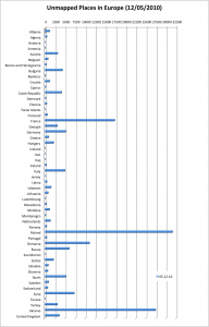
The results showed that of the total 271147 villages, about 156940 villages (58%) who are located within Europe, have not been detected or mapped yet (corresponding to the Geofabrik extract). The following diagram shows the distribution of the numbers by country.
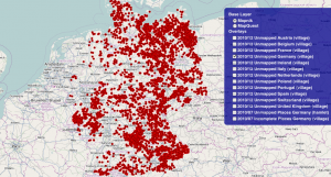
The results can either be displayed as a GPX-overlay on an OSM-map which can be found http://resultmaps.neis-one.org or they can be downloaded as a *.zip file that includes the results for all countries that have been included in the analysis (see at the End!).
Remarks for http://resultmaps.neis-one.org :
- Not each and every country is available as an overlay.
- Some countries such as France, Poland and Ukraine showed longer browser loading times to display the GPX-overlays.
There is a possibility that some of the “places” have been mapped by now. Currently there is a lot of work being contributed to OSM with the help of the new BING aerial images!
thx @ VBA Dennis 😉
Download Unmapped Places GPX *.zip file: 20101205_results_unmapped_eu.zip


Comments
17 responses to ““Unmapped” Places in Europe?”
[…] This post was mentioned on Twitter by Pascal Neis, mac_do. mac_do said: RT @pascal_n: New blog post: "Unmapped" Places in Europe? http://neis-one.org/2010/12/05/unmapped-places-eu/ #OSM […]
Nice. You’ve inspired me to write a wiki page here: http://wiki.openstreetmap.org/wiki/Completeness about ‘Completeness’ with a list of links to tools/analysis like this.
Hi Pascal,
Can you just clarify what this tool is picking out? From the German blog entry and looking at the tool it seems to be identifying villages which have a place node in OSM but no surrounding detail (amenities, residential roads, etc). So this village in Wales, for example, is flagged up because it sits next to a through-road with nothing else nearby:
http://www.openstreetmap.org/browse/node/419347165
Is that right? It’s a very handy tool, by the way, thanks!
Hi Tom,
Sorry, but I should have explained my analysis in more detail in this post (in the German one I actually did it 🙁 ). However, I added some short sentences below.
The tool works so far as followed (Please remember that this is a beta version):
1. Get only places with a village-tag.
2. Search nearby (ca. 600m distance) for a street with one of the following highway-types: residential, service, living_street, cycleway, footway, pedestrian, steps or platform.
3. If no street can be found, mark the place as “unmapped”!
Remember: A village should usually have at least one of the roads mentioned above. Otherwise the place should be mapped as a hamlet?
Surely it’s possible to improve this algorithm, but I think the first results are quite good, aren’t they?
Thanks Pascal, I think it’s great.
Hi Pascal,
thanks for this very useful map. Could you add a link to jOSM RemoteControll and Potlatch? This would speedup the workflow.
Henning
Hi Henning,
Thanks for noticing this idea. I’ve added the links 🙂
The link to .zip-file is broken.
Mhm, strange, should now work …
…shouldn’t the “unclassified” type be part of that list? Remember, that’s not the same as unknown (“road”).
I don´t think that this would be a good idea. An “unclassified” road type describes a connection for example between two villages.
From the OSM Wiki: “Unclassified roads typically form the lowest form of the interconnecting grid network.” http://wiki.openstreetmap.org/wiki/Map_Features
Did you find any examples in the results that would fit to this situation? If so, I would be glad to look into it.
Ich hab mir das letzte Woche und heute nochmal angeschaut. Wenn man meint, mann könnte die jetzt schön abarbeiten irrt man sich. Fast immer wenn ich einen Ort bearbeiten wollte, war er schon gut gemappt. Ich sehe 3 Probleme:
– Aktualität – wie du selbst schon schreibst, zeichnen grad viele Leute von Bing ab. Vielleicht kannst du das per Skript automatisch jede Woche updaten?
– Definition von ungemappt. Mir ist unklar, wie die Kriterien genau sind. Kannst du die nochmal erklären. Cool währe natürlich wenn in den Popup-Dialogen der Karte ein Wert dazu wäre. Wie z.bsp. Straßen in Umkreis von X. (Daran erkennt mann ob jemand anderes schon da war oder es ein false-positiv ist.
– Falsch gemapte Orte – oft sind winzige Orte die eigentlich Weiler sein müssten als villages gemapt.
Michi
PS: Bin gar schlich und einfach zu faul zum englisch schreiben gewesen… 😉
@Michi
Ich schreib dir jetzt auch mal auf deutsch zurück, weil die Fragen tlw. auch in englisch bereits beantwortet wurden 🙂
Ich versuche in der kommenden Woche die Analyse nochmal zu wiederholen. Da aber Weihnachten vor der Tür steht, kann ich leider nichts versprechen. Die Analyse ist eigentlich recht einfach gehalten: Wenn eine Place-Node vom Typ village ist, wird eine Umkreissuche gemacht und geschaut ob sich ein Way mit einer der folgenden Typs im Umkreis von ca. 600m befindet: residential, service, living_street, cycleway, footway, pedestrian, steps or platform. Befindet sich kein solcher Way im Umkreis wird die Place-Node als “unmappt” markiert. Wie du auch bereits erwähnst, ist das mit den “falsch”-verwendeten Place-Type (viallage vs. hamlet) so eine Sache, sie wird aber auch durch diese Analyse aufgedeckt 🙂
Hi, I think the statistic would make more sense if the numbers were divided by the number of place nodes in the considered area and multiplied by the population density. The case in Poland is that (while there are indeed many completely unmapped real villages) it is disproportionally complete in terms of place names. The categories may indeed be wrong because the place names had mostly been imported as villages even if they aren’t a real village, just a named/populated place. There was an import of GNIS place names in 2007 and later this data was updated and complemented with data from another crowd-sourced map project.
@Andrew
Thanks for your sugesstion. Indeed a more detailed statistical analysis per country makes sense. But I don’t quite understand what you mean with: “… if the numbers were divided by the number of place nodes in the considered area and multiplied by the population density. “
Concerning the “unclassified” type, it is commonly found in the countryside for small villages where there is no residential road as such. If I refer to the wiki (http://wiki.openstreetmap.org/wiki/Tag:highway%3Dresidential), I see “residential – street or road generally used only by people that live on that road or roads that branch off it”. This does not match for roads used for transit, but where houses are found all along.
I suggest to add it to your algorithm if you want to focus on missing villages otherwise the result will be significantly higher than the reality.
An example here: http://resultmap.neis-one.org/?zoom=14&lat=49.12307&lon=-0.66364&layers=B0FFTFFFFFFFFFFFT
@Guillaume
Again, I don’t think this is a good idea. Did you have any street data imports, besides the building-import in France? In my opinion, for the example link above, some streets should be better tagged as residential then as unclassified, what do you think ? However, it seems that some streets are still missing, or are there no ways to all those houses ? In Germany we would have the problem, if we add unclassified to the algorithm, some villages will be marked as mapped, but they are still unmapped. Overall not an easy problem …