Tag: New

Reviewing OpenStreetMap contributions 1.0 – Managed by changeset comments and discussions?

The OSM project still records around 650 new contributors each day (out of almost 5,000 registered members per day). Some countries (such as Belgium or Spain) already provide platforms to coordinate the introduction to OSM for new mappers. Others use special scripts or intense manual work to send the newly registered contributors mails with useful information (Washington or The Netherland). However, oftentimes new contributors make, as expected, beginner-mistakes. Personally, I often detect unconnected ways, wrong tags or rare fictive data. Unfortunately, sometimes (new) members also delete, intentionally or unintentionally, existing map data.

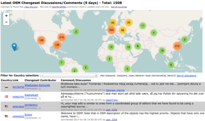
At the end of 2014, many people were anticipating the newly introduced changeset discussions feature. A few months later, I developed a page that finds the latest discussions around the world or in your country. By now, many OSM members use changeset discussions for commenting or questioning map edits of other members.
main

489 Pages about OpenStreetMap

The first book about the OpenStreetMap (OSM) project was written by Frederik Ramm and Jochen Topf, two well-known OSM enthusiasts, in 2008. The first version was in German which was later translated into an improved English version. It contains similar information as can be found in the book by Jonathan Bennett, which was published in 2010, detailing how the projects’ geodata is collected, which editors can be used, some explanations about tags, key and values and how the rendering stack works. Both books are great resources to learn about the OSM basics and to get an overview about useful software.

However, besides these more technical books, the research community has been very active in recent years and has published several articles about OSM data quality, conflation attempts with other datasets or about the contributors of the project. Each of us (Dennis Zielstra and I) wrote a dissertation with different aspects about crowd-sourced geodata and the OSM project: Dennis’ work is about OSM data quality in comparison to proprietary and governmental data with emphasis on pedestrian shortest path routing and data imports. Pascal’s work tackled the issue of how user-generated geodata can be utilized for disabled people friendly route planning. Both dissertations contain more than 13 publications in total.

Welcome to an additional family member – OSMstats

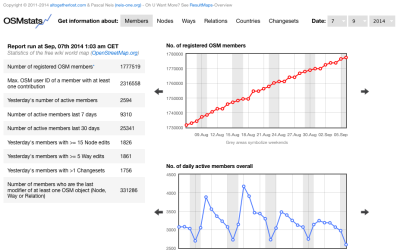
Maybe some of you are already familiar with “OSMstats”, a website that provides numerous statistics about the OpenStreetMap (OSM) project. The site was created and is maintained by the two guys at altogetherlost.com. However, OSMstats has now been moved to the ResultMaps domain at osmstats.neis-one.org. I added several new features too. First of all, you can now select a specific date for your stats. Secondly, the main menu panel has been extended with a new entry for statistical information about OSM changesets.

osmstats

Additionally, the graphs for the country statistics, the active members and daily edits are also available in a “year”-overview. I hope you like the new extensions. A big thanks to both guys at altogetherlost.com who originally created OSMstats!

OSMstats is now available at: http://osmstats.neis-one.org
Feel free to check out my Resultmaps too which offer many helpful and funny OSM tools: http://resultmaps.neis-one.org

Notice: OSMstats was introduced in 2011, this means the webpage cannot provide statistics prior to that year. Also, the newly created Changeset-Tab has only data for July, 2014 and after.

New OSM Contributor Feed

The OpenStreetMap project keeps attracting more and more new members that register and start contributing their data to the project. In one of my last blog posts I presented a website which shows the location of each new and active member based on one of their first edits. Since the launch of this website, some of you asked me about a potential opportunity to feed this information for a particular area. Well, there you go!

You can create your own bbox of interest to determine the area in which you would like to be informed about new members. All you need is the center coordinates (lon & lat) of your area. The following URL is an example for Berlin (Germany):
http:// resultmaps.neis-one.org/newestosmfeed.php?lon=13.3&lat=52.5&deg=1

Where are the new OpenStreetMap Contributors?

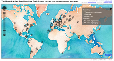
Since past Friday the OpenStreetMap project has more than 600 000 registered members. As many of you may know, not every new registered member starts contributing to the project right away. Based on my “How did you contribute to OSM?” database I created a small (but neat) webpage which shows where the newest registered OpenStreetMap (OSM) members made one of their first edits. The following image shows a screenshot of the new webpage:

The visualized data will be updated on a daily basis. At the moment there are two layers available: one layer displays the latest members of the past two days, while the other layer does the same for the past seven days. At lower zoom-levels the icons are clustered and only show the number of new members. However, on higher zoom-levels you can click on the individual icons to get further information about the new project member. Thanks to Stamen for their really nice looking watercolor map. Would you like to see more statistics about the number of new contributors for each individual country?

Welcome to the new OpenStreetMap Contributors! The beginning of a radical change?

Many blog posts reported in the last few weeks about Google’s changes to their Google Maps API and the new usage limits. If a website that implemented the Google Maps API receives too much traffic or hits e.g. more than 25,000 per day, charges will apply [1]. This news caused some websites to start looking for alternatives and some of them switched to the OpenStreetMap (OSM) project. You can read more about how and why you should also switch to OSM on the great switch2osm.org webpage.

As maybe some of you already know two prominent examples that switched to OSM within the past two weeks are Foursquare and Apple. You can read more about Foursquare’s switch here and about Apple here. Richard Fairhurst wrote a few days ago (on March 8th [2]) that the OSM Project was experiencing a nice boost in several categories such as:

  • more map tiles than usual that have been requested
  • new members on the OSM IRCs asking on how to make changes to the OSM data