Tag: Edits

Review requests of OpenStreetMap contributors
– How you can assist! –

The latest version of the OpenStreetMap editor iD has a new feature: “Allow user to request feedback when saving“. This idea has been mentioned in a diary post by Joost Schouppe about “Building local mapping communities” (at that time: “#pleasereview”) in 2016. The blog post also contains some other additional and good thoughts, definitely worth reading.
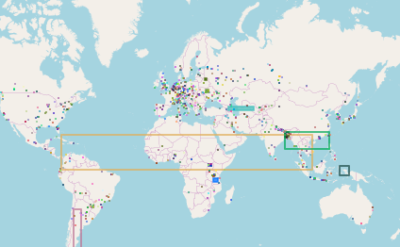
However, based on the newly implemented feature, any contributor can flag her/his changeset and ask for feedback. Now it’s your turn! How can you find and support those OSM’ers?

  • Step 1: Based on the “Find Suspicious OpenStreetMap Changesets” page you can search for flagged changesets, e.g. limited to your country only: Germany or UK.
  • Step 2: Leave a changeset comment where you e.g. welcome the contributor and (if necessary) give her/him some feedback about the map changes. You could also add some additional information, such as links to wiki pages of tags (map features), good mapping practices, the OSM forum, OSM help or mailing lists. Based on the changeset comment other contributors can see that the original contributor of this changeset already has been provided with some feedback.
Verified OpenStreetMap contributor profiles?

The reputation of a contributor in OpenStreetMap (OSM) plays a significant role, especially when considering the quality assessment of the collected data. Sometimes it’s difficult to make a meaningful statement about a contributor by simply looking at the raw mapping work represented by the number of created objects or used tags. Therefore, it would be really helpful if we would have some additional information about the person who contributes to the project. For example: Does she/he help other contributors? Is her/his work somehow documented or based on one of the “discussed” proposals? Or does she/he work as a lone warrior in the OSM world?

In 2010 I created “How did you contribute to OpenStreetMap?” (HDYC) as a kind of fun side project. Nowadays many people use it to get some detailed information about OSM contributors. Some of you are probably familiar with the “verified” icon used on some celebrity Twitter accounts. I created a similar new feature for the aforementioned HDYC page. If you connect your related OSM accounts, your profile will be marked as “verified”.

The OpenStreetMap Contributors Map aka Who’s around me?

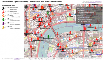
The wait is over! As I mentioned in December, I have been working on an interactive online map, which shows you all volunteers of the OpenStreetMap world on a map. The first three layers contain the activity center of a contributor, her or his first created and latest modified node. The algorithm to determine the activity area of an OSM volunteer has been described in my publication here. I should mention that I used all changeset centers instead of all created nodes of a contributor. This way the computations don’t take as long and the process can be repeated every week based on the weekly OSM changeset dump.

The above image shows the created map for the center of London. As you can see, there are several Mapper-Types to choose from on the left side. Each mapper type is distinguished by the number of changesets that were created (shown in parentheses). However, most of the time you will see many orange or red figures on the map , which means that the OSM project has a lot of members who only made a few changes. This “issue” or “phenomenon” has also been mentioned in the publication.

Nur 1% der User in OSM aktiv?

Im letzten Post habe ich verschiedene “Statistiken” bzgl. der Nutzeraktivität von OSM in Deutschland gezeigt. Manche empfanden das diese “nichts aussagen” oder das “es ja klar ist, das größere oder bevölkerungsstärkere Länder automatisch mehr Edits haben”. Letzteres war zwar im Vorfeld denkbar, wirklich bewiesen hat es aber niemand, oder? Mir ging es eigentlich nicht darum zu zeigen, dass in den größeren Bundesländern in DE mehr los ist, sondern ich wollte vielmehr einmal Zahlen herausfiltern, um damit darzustellen, wie viele Leute denn in jedem Bundesland aktiv an der Karte arbeiten. Ok, etwas “Kritik” könnte man vielleicht am Zeitraum der Analyse (1 Woche) ausüben, es war ein Feiertag dazwischen, aber macht dies wirklich etwas aus? Waren also evtl. an einem Tag mal 50 User mehr oder weniger als einem anderen Tag aktiv? Macht sich das bei einem Mittelwert über eine Woche überhaupt bemerkbar? Da es sich, wie bereits erwähnt, vielmehr um eine “aktuelle” Angabe der aktiven User handelt, denke ich, ist dies hier mal vernachlässigbar. Vielleicht wird OSM.org kommende Woche wieder „geheist“ und dann sehen die Stats bzgl. der User wieder anders aus.

Wo erfolgen die meisten Edits in OSM?

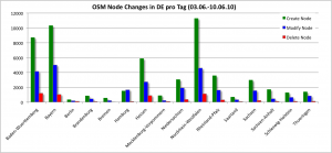
Angeregt durch den vorletzten Post über die „zunehmende“ Anzahl der Fehler in OpenStreetMap DE stellte sich mir die Frage: In welchem Bundesland wird derzeit am meisten an der Map gearbeitet? Aus den daily-Planet-Changefiles für den Zeitraum vom 3.6. bis zum 10.06.2010 (1 Woche) habe ich mal die mittlere Anzahl der Node Edits pro Tag für jedes Bundesland in Deutschland ausgewertet (Edits an Ways sind in diesen Diagrammen (noch) nicht enthalten).

Im Diagramm fallen die drei „großen“ Bundesländer auf. Nordrhein-Westfahlen ist ebenfalls wieder im vorderen Feld der Statistik dabei. Diesmal aber im positiven Sinne 😉 . Bei der Statistik zum Routing View Analyse war es genau andersherum, dort war es das Bundsland mit den meisten Fehlern im Landesvergleich, (vgl. Statistik). Also somit ist NRW das wohl derzeit aktivste Bundesland in OSM DE, aber auch das mit den meisten Fehlern?!

In den Mailinglisten oder auch in den Foren liest man immer wieder eine etwas unterschiedliche Zahle wie groß denn die Beteiligung der deutschen Mapper an der OSM Karte ist. Im folgenden Diagramm sind die Anzahlen der Mapper pro Bundesland für DE für den oben angegeben Zeitraum, die dort einen oder mehrere Edits ausgeführt haben, zu sehen.