And again, here are the new statistics for the “Routing View EU“.
Overall (according to the Geofabrik extract) the following amount of errors appear for Europe at the middle of November 2010:
- Unconnected Roads: ca. 107500
- Duplicate Ways (number of duplicate segments): ca. 160000
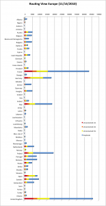
Unfortunately this means that overall only 500 unconnected streets and 22000 duplicate way segment errors have been fixed (last month we had 108000 unconnected roads and 180000 duplicate way segments errors). As always, the following image shows the amount of errors divided by country:
Wow Italy! It’s really nice to see what’s happening there! During the past month they fixed more than 9000 errors again. And now they are really catching up with Germany 🙂 But also in several other countries some people were able to reduce the amount of errors too, such as in: Albania, Denmark, Greece, Iceland, Norway or Sweden. More than 1000 errors have been fixed here in each country 🙂
Slightly disturbing is the situation in Germany: A gain of more than 3.000 errors! What’s going on?! 🙁
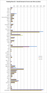
The comparison for each month and country can be seen in the following diagram. (The bars shows the total amount of errors for 1m, 2m, 5m unconnected & duplicate way segments):
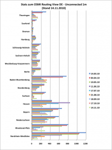
As usual, the comparison of federal states of entire Germany that included the error type “Unconnected 1m”:
Overall, nearly all federal states have a positive value regarding the amount of errors 🙁 Not quite good, especially considering the numbers of the past few months. So tell me…what’s going on in Germany? Are you not interested in fixing errors in the map or database?? What do you think is the problem?
thx @ dennis and Good Luck to you for Thursday!


Comments
8 responses to “Routing View EU 2010-11”
[…] This post was mentioned on Twitter by Pascal Neis, 1001100. 1001100 said: Routing View EU 2010-11 http://tinyurl.com/2vn92xq […]
Well I guess there aren’t that much people out there that use OSM for routing. So this might be a reason that nobody fixes anyhing (well I don’t do it, too).
So we might think about releasing easy to use routing software and a Project of the week adressing this bugs? Now it becomes to cold to walk out and map, so people might be interested in bug fixing?
Mhm, in my opinion several people AND contributors used OSM for routing. And if you remember, some time ago in Germany many errors in the OSM street network were fixed. But sadly it seems that this process has been slowing down since the past month…
But fixing errors is not a lot of work though. The OSM Inspector is a great tool for doing that kind of job. I think, as I mentioned above, that people are not really interested in fixing errors in the database or we still do not promote our QA-tools enough, do we?
Due to your post I’ve recently been on a small campaign to quash some of the blue ‘duplicate way’ sections around the areas in the UK that I’m interested in… gradually increasing the radius cleared. It’s actually a pretty rewarding task as you can see the error free space expanding out and feel like solid progress is being made. So thanks for posting!
I’m only really tackling duplicate ways at the moment as these are generally easier, apart from when there is a tag conflict requiring local knowledge.
This probably is the wrong forum to ask but here is a section I don’t know how to deal with: http://tools.geofabrik.de/osmi/?view=routing&lon=0.15034&lat=52.19857&zoom=18&overlays=duplicate_ways
There are two ways, not overlapping, but indicated as being so. There is a two node one way segment showing cars can only go one way down the street and then another 3 node way showing that bicycles can go the other way. I’ve seen at least one other instance of this in the Cambridge area. How should it be tackled? (Looking to have a sheet clean of blue dots!)
Bug is fixed, can you check it? Thanks again …
@Pete – nice to hear that the post inspired you to fix some errors in the OSM data 🙂
I think the problem that you are mentioning is usually considered as an “error”. In my opinion it’s a better solution to use the following tags to indicate that cycling in opposite direction is allowed: http://wiki.openstreetmap.org/wiki/Key:cycleway
BUT apparently in the UK this is handled a little bit differently. Those “cycle plugs”, that form a little triangle, are right and I have to fix this in my tool. Thx for noticing …
Hey Pascal,
Thanks for that. It seems fixed for some cases, though I’ve found one that isn’t:
http://tools.geofabrik.de/osmi/?view=routing&lon=0.12215&lat=52.20732&zoom=18&opacity=0.34&overlays=duplicate_ways
I guess the data might not have been reprocessed yet, but was wondering if it’s because this plug seems to have 2 nodes that are not on the main way rather than 1 node like the others?
Cheers,
– Pete
@Pete – Hmm, is this way an oneway or is it allowed for both directions?
http://www.openstreetmap.org/browse/way/37793115
If it’s a plug, it should be an oneway, isn’t it?