Tag: User

Ebola Response Map and OSM contributor analysis

For almost eight months the OpenStreetMap (OSM) community has been collecting geo information for the West Africa Ebola outbreak response now. The collective work of the crowd is somewhat managed by the Humanitarian OpenStreetMap Team (HOT). For example, the Task Manager provided by HOT gives interested contributors information in which areas map features are needed. However, you can find additional information in an article by Pierre Beland, which he wrote during a conference where he presented the efforts of the OSM community. The OSM wiki contains some useful information about the West Africa Ebola Response too. Matt Irwin also wrote a summary about the OSM mapper contributions and created an interesting visualization of all the mapping work.

I created a response map for the OSM mapping activities in West Africa, a similar approach as I previously used for the “Typhoon Haiyan” deployment. It displays all OSM changesets created since March 1st, 2014. The analysis extent is displayed by a black rectangle. In total, more than 2,000 contributors made more than 10 million changes to the map. At the bottom you will find a time range slider which can control the displayed changesets. Sorry for the sometimes slow performance, but the community (maybe you too) collected a huge amount of data! The map is online here: http://resultmaps.neis-one.org/osm-ebola
The OSM Contributor Activity Report – Edition 2014

The OpenStreetMap (OSM) project celebrated its 10th anniversary in August 2014. For almost 10 years it has increased its number of registered members. Even though some contributors stopped their contributions to the project, each day new mappers start collecting features for the free wiki world map (aka database).

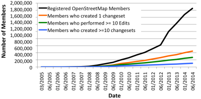
In my last contributor report in 2013, the OSM project had a total of 1.3 Mio registered members. For July 2014 this number has increased to almost 1.6 Mio registered members. Similarly to last year, I checked how many contributors created one or more than ten changesets or performed more than 10 map edits. This information can be retrieved from the changeset dump.

NewContributorsPerMonth.201408

The figure above reveals a similar trend to the ones we saw in the past few years: Less than 1/3 of the 1.6 Mio registered members actively contribute to the project (450,000 members). Furthermore, only a small group of 16% (270,000) or respectively 6% (100,000) of the contributors performed more than 10 edits or 10 changesets.

It’s about time – OpenStreetMap Contributor Activity Report 2013

One and a half years ago (end of 2011), one of my open access publications (“Analyzing the Contributor Activity of a Volunteered Geographic Information Project — The Case of OpenStreetMap“) was published. It contained several interesting findings about the contributions made by the community of the OSM project. The results showed that the community follows a particular pattern that many other online community based projects tend to struggle with too. Only a small number of the members really contribute in a meaningful way to the project. Additionally, the publication illustrated how many contributors are located in Europe and other areas of the world and how and where mappers contribute data over a certain period time.

I thought it was time to update this information with some new statistics. Between the end of 2011 and July 2013 the number of registered OSM members has increased more than two-an-a-half times to almost 1.34 Mio. Based on the freely available changeset dump of the project it is quite easy to check how many members created at least one changeset and thus hopefully made an edit to the database. The following figure shows the increase of registered members and the aforementioned results of the analysis of the changeset dump of July 31st, 2013.

Add a Note in OSM … Stats & Personal Profiles

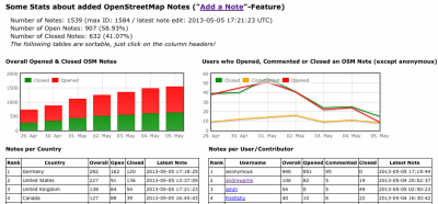
Since April 23th, 2013 each visitor, user or contributor of the OpenStreetMap (OSM) project can “add a note” to the map in order to easily mark an error or missing object in the map data. You can find more information about this new feature in the OSM wiki. It is a great new way for people to contribute to the project by improving the data in a simple way. To provide a better overview I created a new webpage which shows some statistics about the new feature. You can find it here: resultmaps.neis-one.org/osm-notes

Besides some general information the webpage also shows the overall, opened and closed number of notes per country. The second table illustrates the OSM contributors who already opened, commented or closed a note. All tables on the page are sortable by clicking on the column headers.

Additionally I integrated the individual contributor note stats to the OSM personal profiles @ “How did you contribute to OpenStreetMap?“. The following image shows the new add-on, of course with Harry, our guinea pig No. 1, and as always, great work here too! 🙂

The OpenStreetMap Contributors Map aka Who’s around me?

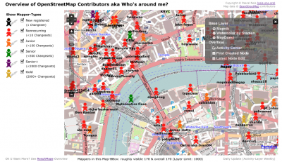
The wait is over! As I mentioned in December, I have been working on an interactive online map, which shows you all volunteers of the OpenStreetMap world on a map. The first three layers contain the activity center of a contributor, her or his first created and latest modified node. The algorithm to determine the activity area of an OSM volunteer has been described in my publication here. I should mention that I used all changeset centers instead of all created nodes of a contributor. This way the computations don’t take as long and the process can be repeated every week based on the weekly OSM changeset dump.

The above image shows the created map for the center of London. As you can see, there are several Mapper-Types to choose from on the left side. Each mapper type is distinguished by the number of changesets that were created (shown in parentheses). However, most of the time you will see many orange or red figures on the map , which means that the OSM project has a lot of members who only made a few changes. This “issue” or “phenomenon” has also been mentioned in the publication.

OSM-Gravatar, Changeset changes & Way-Tags @ HDYC

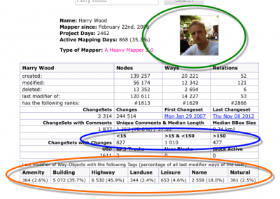
After my latest updates to the “How did you contribute to OpenStreetMap?” website, some users asked me if I could add the new OSM gravatar to it. Starting today, you can find your OSM-gravatar from your OSM user website on HDYC too. If your HDYC-profile doesn’t show a gravatar yet, please be patient. It will be automatically updated as soon as you make any type of OSM edit to the OSM database. The following figure contains all updates that were made to the website marked with a circle. As always, Harry is our example 😉

As a second update, I added the number of changes that were made in a user’s changeset and grouped them into three classes. This way the website shows if a user only makes a lot of changesets with 15 or less edits, more than 150 edits or something in between. Last but not least, you can find some additional information about the number of ways of which the user is the last modifier, including its way tag. This provides some information about the data collection tendency of the contributor, for instance if the user only creates a lot of buildings or large landuse areas.

Overhauling “How did you contribute to OpenStreetMap?”

My last update about the HDYC website is a few months old now. For those readers who do not know what HDYC is: “How did you contribute to OpenStreetMap?” is a webpage which shows you in detail how long, when, where a member of the OSM project contributed to the project and which tools she/he used.

This time I added some new stats and graphs to the site. One of my favorite new features is the location information which shows the countries in which a contributor created at least one OSM Node:

A second new feature shows how long the mapper is already registered with the project and how many *active* mapping days she/he had:

You can also find some more information about the changesets of the user e.g. the number of changesets with a comment, the number of unique changeset comments and the median character length of the comments. Additionally, you will also see some information about deleted nodes, ways or relations:

New OSM Contributor Feed

The OpenStreetMap project keeps attracting more and more new members that register and start contributing their data to the project. In one of my last blog posts I presented a website which shows the location of each new and active member based on one of their first edits. Since the launch of this website, some of you asked me about a potential opportunity to feed this information for a particular area. Well, there you go!

You can create your own bbox of interest to determine the area in which you would like to be informed about new members. All you need is the center coordinates (lon & lat) of your area. The following URL is an example for Berlin (Germany):
http:// resultmaps.neis-one.org/newestosmfeed.php?lon=13.3&lat=52.5&deg=1

TimeSlider for “Your OSM HeatMap”

During my really great vacation in Sweden I had some time to do some further adjustments to the well-known “Your OSM Heatmap“-webpage. For the new readers: “Your OSM Heatmap” shows the contributions of an OpenStreetMap user as a heatmap overlay. You can find my blog post with some more information here.

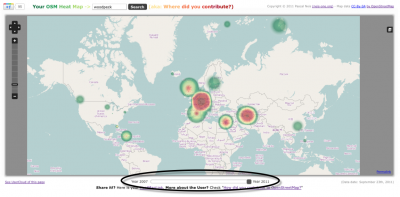
However, I think it would be a fantastic idea to add a time slider to the webpage. You can find it now below the map! The year of your first and last contribution is on the left and right end of the slider. With the slider you can visualize your OSMtastic-work over time. The following image shows the webpage including the time slider:

As a second feature you can now use, beside your OSM heatmap-link, the permalink of the map to point to an individual position of your heatmap! Finally I have updated the data for the webpage with the latest OSM changesets. Overall the heatmaps for about 150 000 contributors are available. Remember: Not *every* registered OSM member did contribute to the project.

“Your OSM Heat Map” (aka Where did you contribute?)

Last week Stephan released the neat “Where Did You Edit?” webpage. A world map indicates where in the world you have been editing OpenStreetMap (OSM) nodes. Unfortunately it is based on a full history OSM planet dump which is nearly two months old. Also, the map does not include any tools to zoom into or drag the map. However, Stephan mentioned that he is working on these functions. Keep up the good work, Stephan!

Based on my OSM changeset table of “How did you contribute to OpenStreetMap ?” I created a slightly different webpage and used a different approach. I used the weekly OSM changeset files and I presented the results in an OpenStreetMap including zoom and drag functions. Your contributions are indicated by a “Heat-Map-Overlay”. For this overlay I am using Bjoern’s OpenLayers addon. For better performance I generalized the total changesets of each OSM contributor. This means that it is possible that not every little contribution from a member is taken into account and displayed in the map. Anyway, I think the results are quite impressive, aren’t they?